| |

Okanogan Complex & Goat Wildfires
Update: Saturday, 9/29
Fire Information: 509-997-0568 | Methownet Fire Page >>
Fires Winding Down
With evacuation levels down and everyone able to go home, roads opening back up, and firefighters mopping up and repairing damage from fire suppression activities, fires around the Methow Valley are winding down. Firefighters are departing.
However, the forest is very dry and fire danger remains high. Campfires are prohibited except in campgrounds or in the Pasayten and Lake Chelan-Sawtooth wildernesses.
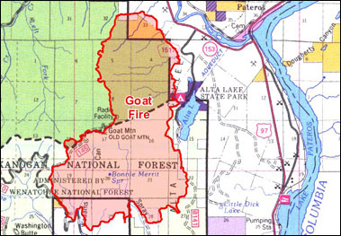
The Goat Fire near Pateros is cooling, mop-up and rehabilitation of impacted areas are nearly completed, according to the final news release from Washington Incident Management Team 5. “Demobilization is in full swing.”
The Goat Fire is now the responsibility of the Chelan Ranger District and the Department of Natural Resources. Other fires are grouped in to the Okanogan Complex, under the Methow Valley Ranger District and Okanogan-Wenatchee National Forest. |

|
All communities in the Methow Valley are open.
- Goat Fire:
7,378 acres, 80% contained
- Leecher Fire:
1,320 acres, 90% contained
- Hunter Fire:
211 acres, 95% contained no visible fire on Friday
- Buckhorn Fire:
4,638 acres, 75% contained
|
Update: Friday, 9/28
Fire Information: 509-997-0568 | Methownet Fire Page >>
Goat Fire (near Alta Lake and Pateros)
The Level 2 Evacuation Notice on homes in the Alta Lake and Quiet Valley areas were lowered to Level 1 yesterday. The fire is cooling, mop-up is nearly completed, and rehabilitation of areas of disturbance is nearing completion. Demobilization is in full swing. Washington Team 5 will transfer responsibility for management of the Goat Fire to the Chelan Ranger District and DNR on Saturday morning at 6 AM. A strong contingent of firefighters will remain on hand to continue patrolling and mopping up the fire. This is the last update that will be provided by Team 5. InciWeb will be updated thru Friday. WIMT5 wants to thank all local community members for their cooperation and support during our time here.
Injuries: No injuries were reported on Thursday
Weather: The forecast calls for temperatures in the 70’s today with winds out of the west of 5-10 mph. Minimum relative humidity is predicted to be 20%.
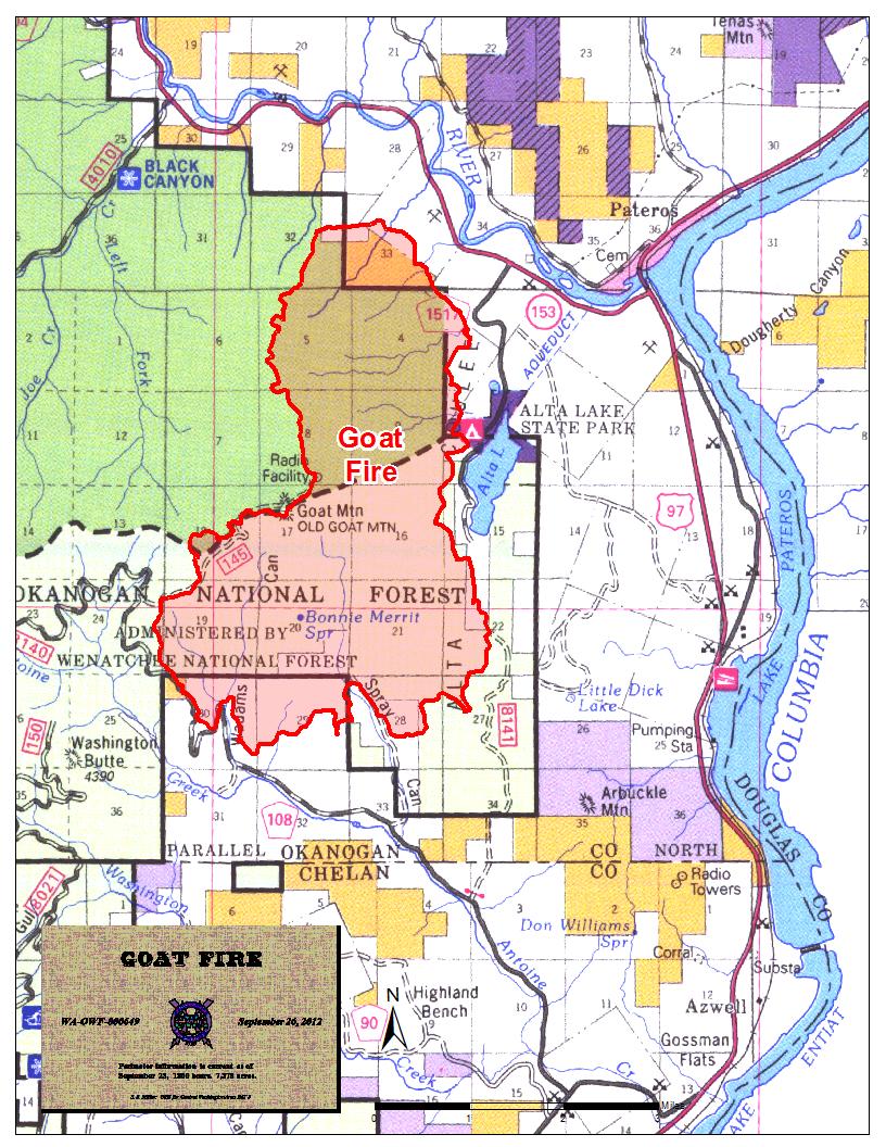
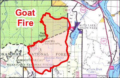
 Click for full map of Goat Fire as of 9/26 Click for full map of Goat Fire as of 9/26
Okanogan Complex Fires (Lower Methow Valley)
Road restrictions and evacuation levels have been adjusted on the Buckhorn Fire. With successful burnout and holding in the Middle Fork, Fire District 6 and Forest Service fire managers feel it is safe to open the North Fork and portions of the South Fork Gold Creek roads. The Middle Fork Gold Creek road will remain closed for firefighter safety for the time being while several crews complete mop-up and hazard tree removal. The Rainy Creek Road will also remain closed for a short period to allow crews to complete the work in that area.
Additionally, evacuation levels in Gold Creek have been lowered. The Middle Fork is now at Evacuation Level 2 and North and South Forks are at Evacuation Level 1. There will still be abundant fire traffic in the area for the next several days. Drivers should be very watchful.
Mop-up and fireline rehabilitation continues on the Leecher Fire.
The Hunter Fire is in monitor status.
Dry conditions and temperatures above normal are expected for the next several days. Fire Danger remains high. Campfires are prohibited except in designated campgrounds or in the Pasayten and the Chelan / Sawtooth Wilderness. |
|
All communities in the Methow Valley are open.
Goat Fire:
- Acres: 7,378 (80% contained)
- Personnel & Equipment:
- 362 people
- 4 bulldozers
- 6 water tenders
- 14 engines
- 1 light lift helicopter
- Evacuations:
- Level 2 (ready to leave): residences on Quiet Valley Road (change from level 3 yesterday); residences west of Golf Course Drive; the south portion of Alta Lake, west side of lake and south of Alta Lake Park; residences in Antoine Creek
Okanogan Complex:
- Acres: 6,169 (80% contained)
- Hunter - 211
Leecher - 1,320
Buckhorn - 4,638
- Personnel: 518
- Evacuations:
- Level 2: Buckhorn Fire Middle Fork Gold Creek
- Level 1: Buckhorn Fire North Fork Gold Creek
- Level 1: Buckhorn Fire South Fork Gold Creek
|
Update: Thursday, 9/27
Fire Information: 509-997-0568 | Methownet Fire Page >>
Goat Fire (near Alta Lake and Pateros)
The Level 2 Evacuation Notice on homes in the Alta Lake and Quiet Valley areas will be re-evaluated today. Demobilization is beginning in earnest and 140 to 150 personnel will begin the “going-home” process today. The fire is cooling, mop-up is being completed, and areas of disturbance are being rehabilitated. Washington Team 5 plans to transfer responsibility for management of the Goat Fire to the Chelan Ranger District and DNR on Saturday morning at 6 AM. A strong contingent of firefighters will remain on hand to continue patrolling and mopping up the fire. This is the last update that will be provided via our community traplines. InciWeb will be updated thru Friday. WIMT5 wants to thank all local community members for their cooperation and support during our time here.
Injuries: No injuries were reported on Wednesday
Weather: The forecast calls for slightly warmer temperatures today and a breeze from the southeast of 5 to 7 mph with gusts of 10-12. Minimum relative humidity will range from 19% to 22%, depending on location.
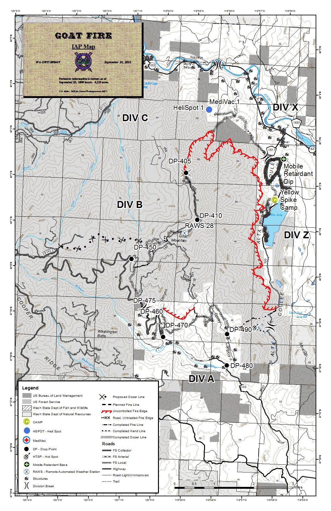
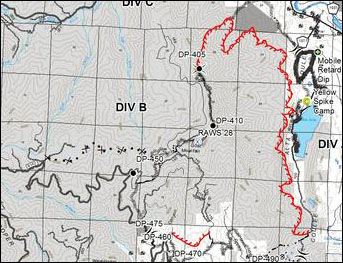 Click for full map of Goat Fire as of 9/24 Click for full map of Goat Fire as of 9/24
Okanogan Complex Fires (Lower Methow Valley)
Crews continue to strengthen and secure firelines on the Buckhorn Fire. Wednesday was another day of careful burnout operations that were completed successfully. Night crews monitored the fire to watch for escapes and control flare-ups near the line. Mop-up will begin today in the Middle Fork of Gold Creek.
Mop-up and fireline rehabilitation continues on the Leecher Fire. Road repair from fire traffic is also under way. Road closures in Benson and Texas Creek have been lifted.
The Hunter Fire is in monitor status.
Fire managers are carefully evaluating risks to firefighters and residents and they will adjust evacuation levels in Gold Creek as soon as appropriate.
Dry conditions and temperatures remaining above normal are expected for the next several days. Fire Danger remains high. Campfires are still prohibited except in Designated Campgrounds or the Pasayten and the Chelan / Sawtooth Wilderness. |
|
All communities in the Methow Valley are open.
Goat Fire:
- Acres: 7,378 (70% contained)
- Personnel & Equipment:
- 510 people
- 2 bulldozers
- 19 water tenders
- 25 engines
- 1 heavy lift helicopters
- 3 light lift helicopter
- Evacuations:
- Level 2 (ready to leave): residences on Quiet Valley Road (change from level 3 yesterday); residences west of Golf Course Drive; the south portion of Alta Lake, west side of lake and south of Alta Lake Park; residences in Antoine Creek
Okanogan Complex:
- Acres: 6,169 (80% contained)
- Hunter - 211
Leecher - 1,320
Buckhorn - 4,638
- Personnel: 518
- Evacuations:
- Level 3: Buckhorn Fire Middle Fork Gold Creek
- Level 2: Buckhorn Fire North Fork Gold Creek
- Level 1: Buckhorn Fire South Fork Gold Creek
|
Update: Wednesday, 9/26
Fire Information: 509-997-0568 | Methownet Fire Page >>
This morning the Oregon-based Type I team handed command of the Hunter, Leecher and Buckhorn fires to locals: the Okanogan and Wenatchee National Forest Type 3 team, led by Chad Bresnaham. The firefighters will remain at their current fire camp near Twisp as they strengthen firelines and mop up, according to a news release.
Firefighters successfully burned out fuels in the northern part of the Goat Fire, working through the night to further secure the fire line. On the remainder of the Goat Fire mop-up and structure protection continued. The Goat Fire is now considered 40% contained: crews expect to have it fully contained by Friday.
Weather predictions are calling for an inversion, which will again trap smoke in the area.
Tuesday, crews on the Buckhorn Fire continued to clear fuels in the Middle Fork drainage lighting with both aerial and hand-lighting tactics. Pockets of diseased timber put up thick smoke. Firefighter focus was to secure residences in the Middle Fork of Gold Creek: that will continue through today’s shift.
As the attack winds down on the Buckhorn Fire, firefighters have been backhauling supplies from helispots and drop points. Tuesday’s night shift crews patrolled and monitored hotspots along the burnout perimeter.
Evacuation levels remain in place until the area is cleared of hazard trees, mopped up and rehabilitated enough that residents are safe to return.
Firefighters are mopping up on the Leecher Fire aiming to cold-trail and suppress any intermittent hotspots one hundred feet inside the fireline. The Hunter Fire is in air reconnaissance status. No heat has been detected in recent flyovers.
Click for full map of Goat Fire as of 9/24
|
|
All communities in the Methow Valley are open.
Goat Fire:
- Acres: 6,912 (40% contained)
- Personnel & Equipment:
- 566 people
- 5 bulldozers
- 15 water tenders
- 23 engines
- 2 heavy lift helicopters
- 1 light lift helicopter
- Evacuations:
- Level 2 (ready to leave): residences on Quiet Valley Road (change from level 3 yesterday); residences west of Golf Course Drive; the south portion of Alta Lake, west side of lake and south of Alta Lake Park; residences in Antoine Creek
Okanogan Complex:
- Acres: 6,169 (75% contained)
- Hunter - 211
Leecher - 1,320
Buckhorn - 4,638
- Personnel: 518
- Evacuations:
- Level 2 (ready to leave): South Fork Gold Creek residences
- Level 3 (leave immediately): North and Middle Fork Gold Creek residence
|
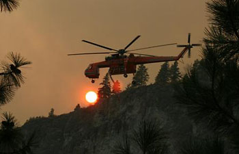
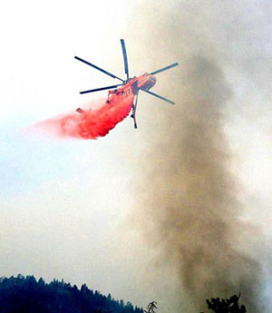 Sky Crane helicopter dropping fire retardant on Goat Fire. Photo by Ranta
Goat Fire (near Alta Lake and Pateros)
Firefighters completed construction of initial fire line around the Goat Fire Monday with the aid of 513 people, five dozers, 15 water tenders and 23 engines plus two heavy helicopters and one small helicopter. They also successfully burned out one section of the fire and hope to burn away more fuel today where it sits between the active flames and the fire line, weather willing. All told, firefighters consider Goat only 25% contained, according to a news release from Washington Incident Management Team #5.
If conditions permit, more burnout operations are planned today on the northwest portion of the fire to remove fuel remaining between the established firelines and active fire. Residents should be prepared to see significant smoke from the Goat Fire in the afternoon. Temperatures are expected to be in the 70’s, with relative humidity at 33%. Northwest winds will begin lifting the inversions and flushing smoke out of the area.
Residents have been allowed back into their homes near the Goat Fire. The Level 3 evacuation (residents must leave) of five homes in the Quiet Valley area changed to Level 2 (be ready to leave) at 10am this morning, according to the news release. Other Level 2 evacuation areas remain unchanged.
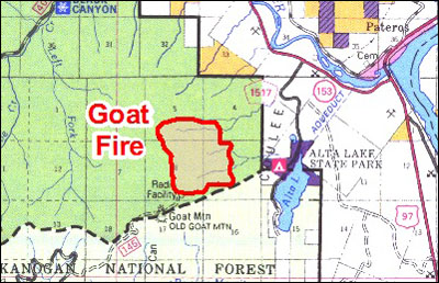
Goat Fire night operations continued protection of structures and critical communication sites along Antoine Creek, Spray Canyon/Quiet Valley, and Alta Lake areas. Inside the Goat Fire fireline are 6,912 acres located about three miles southwest of Pateros.
The fire was human-caused and how it started is being investigated.
Click for full map of Goat Fire as of 9/24
Okanogan Complex Fires (Lower Methow Valley)
Burnout operations continued on the Middle Fork area of the Buckhorn fire yesterday. This was accomplished by both aerial ignition and firefighters on the ground. The fire backed down nicely towards the road in the middle fork of Gold Creek. Today, the remaining small area between yesterday's operation and its intended target will be completed by firefighters with drip torches. Crews with hose lines will be monitoring progression to avoid spots over the line.
The Leecher fire is approching completion of the required mop-up standards. Rehabilitation, backhaul, and gridding will continue today, with end of shift today as a goal.
Weather conditions for this operational period will be 5-10 degrees cooler than yesterday. The humidities will remain in the 30-40 percent range, while the fire will experience weak northernly winds. Fuels that are larger than one half inch in diameter are still dry and will burn, but fire movement is slowing in these types of areas.
Tomorrow morning, Wednesday September 26th, at 6:00 a.m. the command and management of this fire will be transferred to a Type 3 team being managed by the local forest. Camp will continue at its current site for the foreseeable future to continue to support firefighters and other resources that will be remaining to assist in the containment and extinguishment of this complex. |
|
All communities in the Methow Valley are open.
Goat Fire:
- Acres: 6,912 (25% contained)
- Personnel & Equipment:
- 513 people
- 5 bulldozers
- 15 water tenders
- 23 engines
- 2 heavy lift helicopters
- 1 light lift helicopter
- Evacuations:
- Level 2 (ready to leave): residences on Quiet Valley Road (change from level 3 yesterday); residences west of Golf Course Drive; the south portion of Alta Lake, west side of lake and south of Alta Lake Park; residences in Antoine Creek
Okanogan Complex:
- Acres: 6,169 (75% contained)
- Hunter - 211
Leecher - 1,320
Buckhorn - 4,638
- Personnel: 518
- Evacuations:
- Level 2 (ready to leave): South Fork Gold Creek residences
- Level 3 (leave immediately): North and Middle Fork Gold Creek residences
|
Update: Monday, 9/24
Fire Information: 509-997-0568 | Methownet Fire Page >>
Separate Team Takes Over Goat Fire
Sunday evening, the Washington Incident Management Team #5 took on the Goat Fire near Alta Lake. They have set up their base camp at the rodeo grounds in Chelan. About 460 people equipped with six bulldozers, nine water tenders and 27 engines are assigned to Goat Fire which is now 6,110 acres and estimated at 10% contained, burning on both national forest and private land.
Goat Fire night operations focused on protecting structures and critical communication sites near Antoine Creek, Spray Canyon/Quiet Valley, and Alta Lake.
Day operations include continue reconnaissance, construction and strengthening of control lines; burnout; structure protection and fuels reduction.
The Goat fire is listed as human-caused.
Firefighters made progress with along the northwestern perimeter of the Buckhorn Fire, where they burned, removing fuels between the advancing flame front and the Middle Fork of Gold Creek control line. Crews plan to continue burnout operations today to remove any remaining fuel and strengthen containment lines.
Firefighters have spent the past several days preparing for the Buckhorn burnout operation by clearing brush, constructing containment lines, installing hose lays and setting up sprinkler systems to prevent the fire from crossing the creek. Engines will continue patrol throughout the night along the Middle Fork.
Mop-up operations will continue along the South and North Fork of Gold Creek and along portions of the Middle Fork. The upper end of the South Fork is close to meeting the mop-up standards. Firefighters will be using palm-held infra-red technology to continue looking for hot spots.
Rehabilitation, backhaul, and mop-up of containment lines and other areas disturbed by fire suppression will be ongoing on the Leecher Fire, while the Hunter Fire is now in monitor status by air.
Temperatures should approach the 80s in the fire elevations today, with relative humidity in the low 20s. Light winds will change to a westerly direction this afternoon, with gusts 10-15 mph. This should allow the fire to become active earlier in the day, which is needed to help with controlled burn operations. Four aircraft can assist firefighters on the ground.
Click for full map of Goat Fire as of 9/24 |
|
All communities in the Methow Valley are open.
Fires At a Glance:
- Size: 12,083 total acres
- Hunter – 211
Leecher – 1,320
Buckhorn – 4,442
Goat – 6,110
- Personnel: 978 (460 assigned to Goat Fire)
Evacuations:
- Level 2 (ready to leave): GOAT FIRE - Residences west of Golf Course Drive; the south portion of Alta Lake, west side of lake and south of Alta Lake Park; residences in Antoine Creek
BUCKHORN FIRE - South Fork Gold Creek Residences
- Level 3 (leave now):
GOAT FIRE - Residences on Quiet Valley Road
BUCKHORN FIRE - Middle Fork and North Fork Gold Creek residences
|
Update: Sunday, 9/23
Fire Information: 509-997-0568
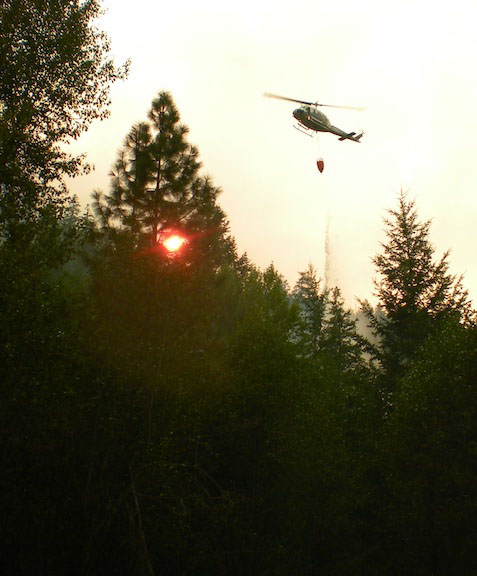
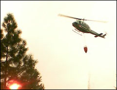
 A Type 1 "heavy lift" helicopter (Sky Crane) working the fires USFS photo The Buckhorn Fire was once again quiet on three sides, giving firefighters opportunity to complete preparations for the final assault. The northwest flank has remained hot and active, and plans are in place today to begin burning out the remaining fuels between the fire and the Middle Fork of Gold Creek.
"We want to strike while weather conditions remain favorable," said Operations Chief Ron Barber. Heavy smoke accumulation or relative humidity above the threshold for ignition are possible factors which would delay the aerial burnout operation. Residents are advised to expect smoky conditions today in the Gold Creek vicinity.
The Goat Fire continues to blaze brightly and conspicuously along the rim above homes near the Golf Course at Alta Lake. As the fire proceeds slowly down the rocky bluffs, firefighters are waiting at the bottom with hoses and sprinklers, dozer lines, engines, and crews to stop it from advancing further. Elsewhere on the fire, the line constructed to the northwest along Adam's Ridge was breached last night. Firefighters will survey the situation today to make containment plans. There was also growth to the southwest.
The Hunter fire was patrolled on Saturday and there were no visible smokes.
The Leecher Fire continues to be checked for hot spots with hand-held infra-red sensors.
Management of the Goat Fire will shift today as Washington Incident Management Team 5 assumes responsibility for suppression activity. Future updates regarding the Goat Fire will be produced separately by the Washington Team. Oregon Incident Management Team 1 will continue to direct activity on the Okanogan Complex, which will consist of the Buckhorn, Leecher, and Hunter Fires. The Oregon Team is working with local agencies to develop a plan to return responsibility for the Complex back to the local agencies.
Suggested websites for those interested in preparing their homes and surroundings for better wildfire survival include www.fireadapted.org and www.firewise.org.
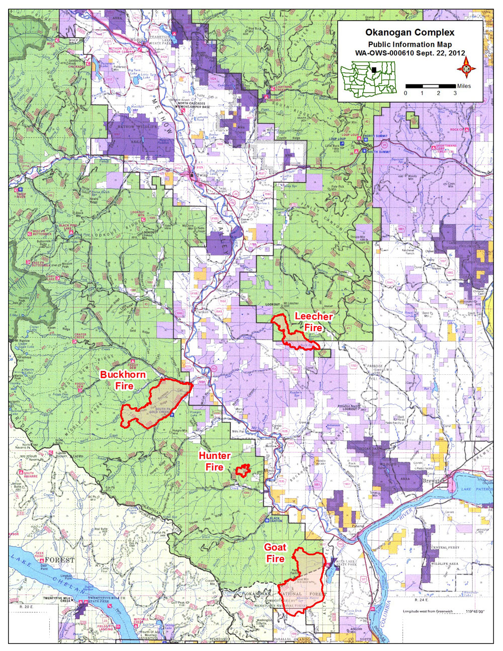
 Click for full map of Okanogan Complex fires as of 9/22 Click for full map of Okanogan Complex fires as of 9/22
|
|
All communities in the Methow Valley are open.
Evacuations:
- Level 2 (ready to leave): GOAT FIRE - Residences west of Golf Course Drive; the south portion of Alta Lake, west side of lake and south of Alta Lake Park; residences in Antoine Creek
BUCKHORN FIRE - South Fork Gold Creek Residences
- Level 3 (leave now):
GOAT FIRE - Residences on Quiet Valley Road
BUCKHORN FIRE - Middle Fork and North Fork Gold Creek residences
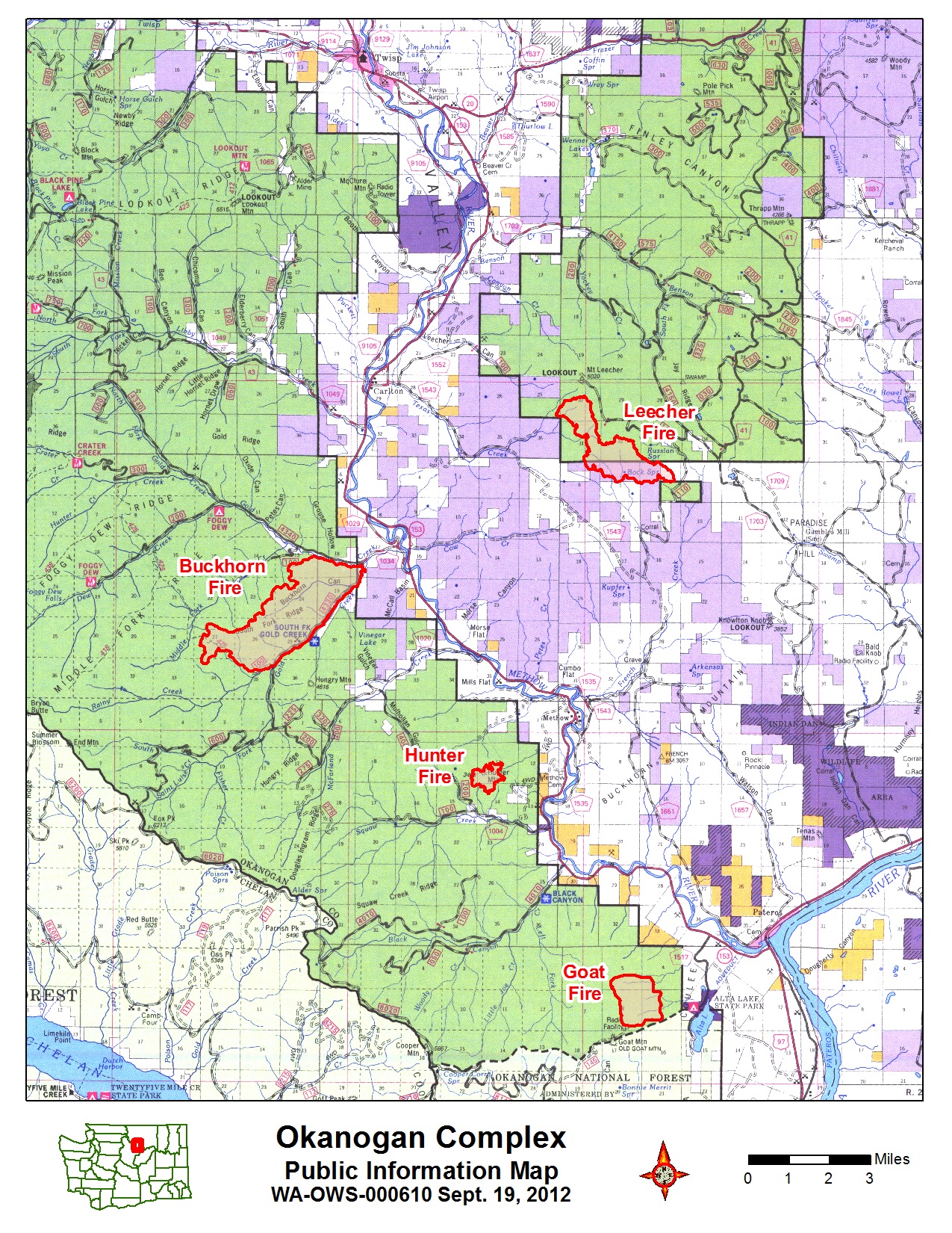
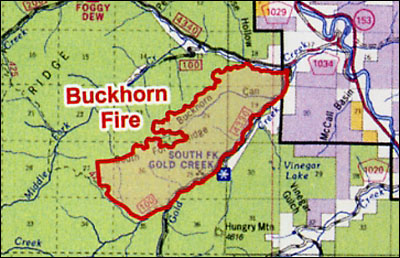
The Okanogan Complex is made up of three lightning fires and one fire with unknown cause in the Methow Valley. The Buckhorn Fire is northwest of the community of Methow, approximately 6 miles. The Leecher Fire is about 6 miles northeast of Methow. The Hunter Fire is 2 miles to the southwest of Methow. The Goat Fire, the newest, is near Pateros at the mouth of the Methow River.
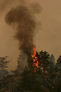 Torching tree. USFS photo |
Update: Friday, 9/21
Fire Information: 509-997-0568
Local television change due to fires:
From the Methow Communications District: While waiting out the fire on Goat Mountain, we've switched our McClure Mountain feed for KSPS to Omak Mountain (Okanogan County TV District 1). They have been experiencing intermittent problems, so you may notice signal degradation from time to time. NOTE: You may need to rescan for channels to pick up the new feed.
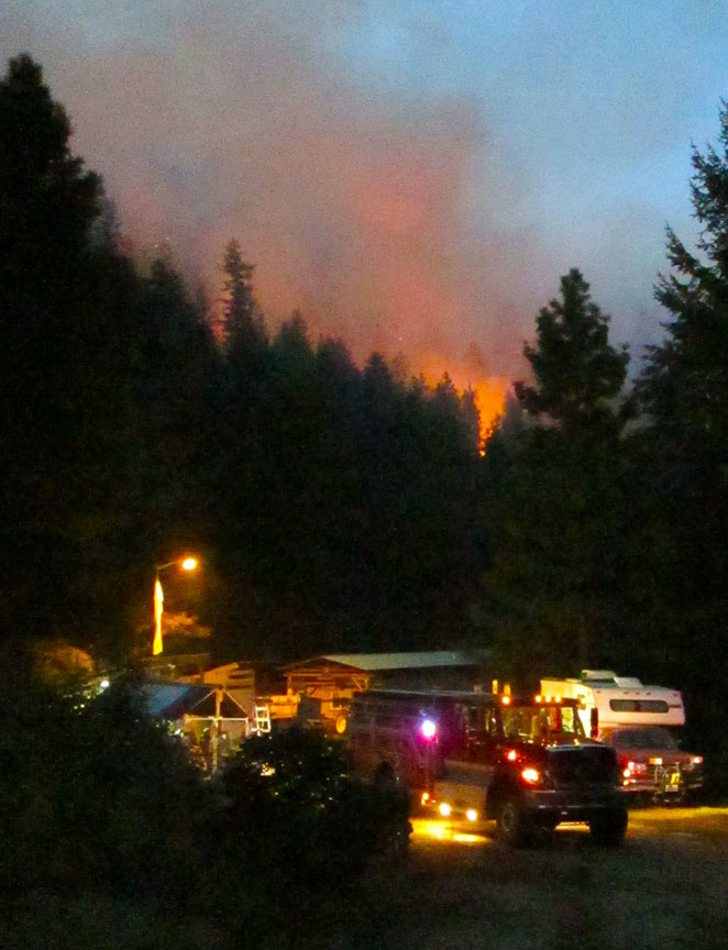
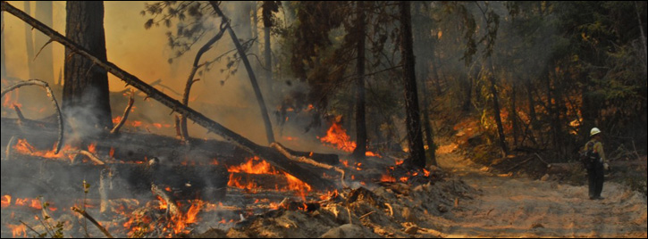
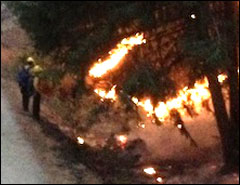
 Structure protection. Photo by Max Jones, Okanogan County Fire District #6 (click to enlarge) Continued warm, dry weather and extremely steep, rugged terrain are hampering firefighting efforts, both on the ground and from the air on the Buckhorn and Goat Fires. The Hunter fire is now in patrol status and the Leecher fire had one spot fire yesterday, but crews are mostly mopping up and rehabilitating fire lines, according to a news release from Oregon Interagency Incident Management Team 1.
The Goat Fire is burning almost 24 hours a day with the majority of fire activity to the south and southwest. "This kind of fire behavior is unusual this late in the season'" states the news release. The Goat Fire also continues to move east, but remains above the bluffs near Alta Lake. Crews are focusing on building and strengthening hand and dozer line along the south and east flanks to protect private land and property. Helicopters have been working steadily, dropping both water and retardant to support ground efforts.
Firefighters are making headway on the Buckhorn Fire though it persists moving to the west. Overnight temperatures on the ridges in Gold Creek were above 60 degrees, allowing the fire to burn into the night. Crews are working day and night to anchor the line on the southwest and northwest corners of the fire, hoping to safely meet the fire as it progresses towards the Middle Fork of Gold Creek. Work continues in the interface between homes and the forest and crews have been successful in preventing any structural damage.
The 17 water tenders assigned to this incident provide critical support to suppression efforts by providing water to engines providing structural protection, as well as watering gravel and roads. Watering the roads is critical to operational safety by reducing dust, ensuring good visibility, and keeping road surfaces from deteriorating.
"With extreme and often unpredictable fire activity in the area, fire managers continue to emphasize that public and firefighter safety is always top priority," says the release. "Adhering to evacuations and closures will help insure everyone makes it through this fire season safely."
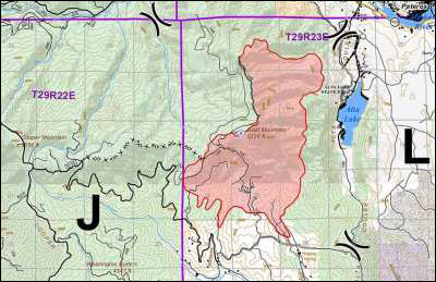 Click for full planning map of Okanogan Complex fires as of 9/21 Click for full planning map of Okanogan Complex fires as of 9/21
|
|
All communities in the Methow Valley are open.
Fires At a Glance:
- Size: 7,331 total acres
- Hunter – 211
Leecher – 1,320
Buckhorn – 3,800
Goat – 2000
- Containment: 18%
- Location: Vicinity of Carlton, Washington
- Cause: Buckhorn, Leecher and Hunter - Lightning (9/8/12)
Goat Mountain – Under Investigation
- Personnel: 786
- Evacuations:
- Level 2 (ready to leave): GOAT FIRE - Residences west of Golf Course Drive; the south portion of Alta Lake, west side of lake and south of Alta Lake Park; residences in Antoine Creek
BUCKHORN FIRE - South Fork Gold Creek Residences
- Level 3 (leave now):
GOAT FIRE - Residences on Quiet Valley Road
BUCKHORN FIRE - Middle Fork and North Fork Gold Creek residences
The Okanogan Complex is made up of three lightning fires and one fire with unknown cause in the Methow Valley. The Buckhorn Fire is northwest of the community of Methow, approximately 6 miles. The Leecher Fire is about 6 miles northeast of Methow. The Hunter Fire is 2 miles to the southwest of Methow. The Goat Fire, the newest, is near Pateros at the mouth of the Methow River. |
Update: Thursday, 9/20
Fire Information: 509-997-0568
Local television down due to fires:
"KSPS (channels 7.1,2,3) and the standard definition channels 2.1, 4.1 and 6.1 are off the air," said communications district technician Paul Brown in a note on the Methownet bulletinboard. "The roads remain closed so there's no ETA for repair at this time."
"The fire at Goat Mountain near Pateros has damaged TV District 3's KSPS receive antenna (TV District 3 is for Brewster/Pateros). Our KSPS feed comes from their site, so it is off the air throughout the Methow Valley (and in the Brewster/Pateros area, of course). The buildings for both districts are okay and most of the fuel around the them has burned so they are probably out of danger.," states the Methow Valley Communications District website.
The unseasonably hot and dry weather in Central Washington continues to spur extreme fire behavior in the fires around the lower Methow Valley, according to a news release from Oregon Interagency Incident Management Team 1. South facing slopes are particularly volatile as fuels dry through the day and relative humidity continues to be low.
Yesterday the Goat Fire near Alta Lake advanced to the south and west. Firefighting aircraft were active all day with retardant and bucket drops.
Wednesday afternoon Level 1 (prepare to leave) evacuations were issued to 16 homes on Antoine Creek Road and six homes on Quiet Valley Road in the Alta Lake area. One home at the end of Quiet Valley Road was issued a Level 2 (be ready to leave) notice, as was one at the south end of Alta Lake.
During Thursday’s operations, firefighters scouted for new containment lines on the west and south. Meanwhile, they were protecting communication towers on the ridgelines.
Air operations are supporting crews with three heavy-lift (Type 1) helicopters, 2 medium-lift (Type 2), and three light-lift (Type 3) helicopters through day shift. Firefighters are from the continental US, Alaska, and Canada.
A Washington Conservation Corp (WCC) crew is on the Leecher Fire assisting with mop-up and ground infrared survey. The WCC is a youth program of Americorp that provides outdoor job experience and college grants for youth.
Campfire restrictions are now in place on the Methow Valley and Tonasket Ranger Districts. No wood or charcoal fires are permitted outside of designated campgrounds. This closure does not apply to the Pasayten or Chelan/Sawtooth Wilderness or the Brevicomis Summer Home Tract.
 Click for full map of Okanogan Complex fires as of 9/19 Click for full map of Okanogan Complex fires as of 9/19
|
|
All communities in the Methow Valley are open.
Fires At a Glance:
- Size: 6,740 total acres
- Hunter – 211
Leecher – 1,320
Buckhorn – 3,720
Goat – 1489
- Containment: 18%
- Location: Vicinity of Carlton, Washington
- Cause: Buckhorn, Leecher and Hunter - Lightning (9/8/12)
Goat Mountain – Under Investigation
- Personnel: 559
- Evacuations:
- Level 1 (prepare to leave) for 16 homes on Antoine Creek road and 6 homes on Spray Canyon/Quiet Valley Road
- Level 2 (ready to leave) for residences west of Golf Course Drive, the last residence on Quiet Valley Road, the south portion of Alta Lake continuing south, and the west side of Alta Lake.
- Level 3 (leave now) for all residences in Gold Creek
The Okanogan Complex is made up of three lightning fires and one fire with unknown cause in the Methow Valley. The Buckhorn Fire is northwest of the community of Methow, approximately 6 miles. The Leecher Fire is about 6 miles northeast of Methow. The Hunter Fire is 2 miles to the southwest of Methow. The Goat Fire, the newest, is near Pateros at the mouth of the Methow River. |
Update: Wednesday, 9/19, morning
Fire Information: 509-997-0568
Firefighters are holding a public meeting tonight at 6:00 p.m. at the Alta Lake State Park to share fire information and answer questions.
The Goat Fire was very active yesterday. Two heavy-lift, two medium-lift, and one light-lift helicopter, as well as a single engine air tanker supported hand crews working the fire according to a news release from the Oregon Interagency Incident Management Team 1.
Crews improved the defensible space around critical communication sites on Goat Mountain. Overnight, down-slope winds pushed the fire rapidly to the south: the fire grew to about about 750 acres.
A Level 2 Evacuation Notice advising residents to be prepared to leave at a moment’s notice has been issued for 21 homes along the west side of the Alta Lake Golf Course. Homes along the west side of Alta Lake are under a Level 1 Evacuation notice. This is a precautionary notice to allow those with special needs, pets, or livestock to make necessary arrangements.
Forest Road 8140-145 to Goat Mountain has been closed.
The Buckhorn Fire also grew and is now approximately 3,550 acres. Crews continue to make progress lining the fire. No structures have been damaged to date. If smoke clears, portions of the Gold Creek Loop Road may be closed again today due to helicopter bucket dipping in the adjacent river.
Yesterday, the Methow Valley was extremely smoky in the fires’ vicinity. As the weather is expected to remain the same through Friday night, smoke in the valley will likely increase.
Beginning Thursday, September 20th, the Okanogan-Wenatchee National Forest will prohibit campfires on the Methow Valley and Tonasket Ranger Districts. This restriction does not apply to designated campgrounds or other specifically permitted areas.
Click for full map of Okanogan Complex fires as of 9/19 |
|
All communities in the Methow Valley are open. Smoke this morning is much less than yesterday afternoon.
Fires At a Glance:
- Size: 5,831 total acres
- Hunter – 211
Leecher – 1,320
Buckhorn – 3,550
Goat – 750
- Containment: 18%
- Location: Vicinity of Carlton, Washington
- Cause: Buckhorn, Leecher and Hunter - Lightning (9/8/12)
Goat Mountain – Under Investigation
- Personnel: 539
- Evacuations:
- Level 1 (prepare to leave) for residences west of Alta Lake as far to the south as Whistling Pines.
- Level 2 (ready to leave) for residences west of Golf Course Drive near Goat Fire
- Level 3 (leave now) for residences in Gold Creek area near Buckhorn fire
The Okanogan Complex is made up of three lightning fires and one fire with unknown cause in the Methow Valley. The Buckhorn Fire is northwest of the community of Methow, approximately 6 miles. The Leecher Fire is about 6 miles northeast of Methow. The Hunter Fire is 2 miles to the southwest of Methow. The Goat Fire, the newest, is near Pateros at the mouth of the Methow River. |
Update: Tuesday, 9/18, morning
Fire Information: 509-997-0568
NEW EVACUATION: Level 1 (prepare to evacuate) for Alta Lake area.
Managers have issued a Level 1 Evacuation Notice for the Golf Course and Alta Lake community - that means ‘get ready’. The precautionary notice allows those with special needs, pets, or livestock to make necessary arrangements, according to a recent news release by Oregon Incident Management Team 1.
Firefighters will talk to the public at a meeting tomorrow (Wednesday) at 6:00 p.m. at the Alta Lake State Park to share information about the Goat Fire.
The Goat Fire, discovered late Saturday night, has grown to approximately 200 acres. Today a 14-person Canadian crew and division supervisor will be joining suppression efforts on the Goat Fire. Approximately 115 Canadian firefighters have crossed the Washington border to assist at three of the large fire complexes in the state.
Crews have been improving the defensible space around communication sites located on Goat Mountain.
The Buckhorn Fire and the Goat Fire are the most active in the Methow Valley drainage. The Leecher Fire and Hunter Fire are both in the mop up and monitoring phase.
The Buckhorn fire is still approximately 3,000 acres. Crews continue to make progress lining the fire. No structures have been damaged to date. Portions of the Gold Creek Loop Road will be closed again today due to helicopter bucket dipping in the adjacent river.
Relative humidity in the Methow Valley has been extremely low several days in a row: the chance of new fire starts and more extreme fire behavior is up. Experts expect smoke to continue to clog Methow Valley skies.
Even though the public may not be able to help on the fire line, their compliance with burning regulations is a crucial part of preventing wildfire in the valley. Grass and vegetation are extremely dry. Any spark can ignite a wildfire. Compliance with road and trail closures also allows emergency responders to more safely complete their jobs, the news release states.
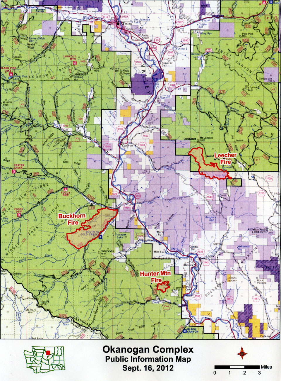
 Click for full map of Okanogan Complex fires as of 9/16 Click for full map of Okanogan Complex fires as of 9/16
|
|
All communities in the Methow Valley are open and are not impacted by the fires, except for increased traffic in the outlying areas.
Fires At a Glance:
- Size: 4,711 total acres
- Hunter – 211
Leecher – 1,300
Buckhorn – 3,000
Goat – 200
- Containment: 18%
- Location: Vicinity of Carlton, Washington
- Cause: Buckhorn, Leecher and Hunter - Lightning (9/8/12)
- Goat Mountain – Under Investigation
- Personnel: 499
- Evacuations: A Level 1 evacuation will go into effect Tuesday afternoon 9/18 for homes on the west side of Golf Course Drive and on the west side of Alta Lake as far to the south as Whistling Pines.
A Level 3 evacuation is in place in the Gold Creek area near the Buckhorn Fire
The Okanogan Complex is made up of three lightning fires and one fire with unknown cause in the Methow Valley. The Buckhorn Fire is northwest of the community of Methow, approximately 6 miles. The Leecher Fire is about 6 miles northeast of Methow. The Hunter Fire is 2 miles to the southwest of Methow. The Goat Fire, the newest, is near Pateros at the mouth of the Methow River. |
Update: Monday, 9/17, afternoon
At 6:00 AM, Oregon Incident Management Team #1 assumed control of the Goat Fire. The team is managing the three other wildfires in the Okanogan Complex. The now 94-acre Goat Fire was found on Goat Mountain near Pateros Saturday night. It is burning in steep rugged terrain where fire behavior was very active yesterday, with running fire, single and group tree torching and short-range spotting. Cause of the fire is still under investigation.
The Buckhorn Fire also had very active fire behavior in the late afternoon on Sunday. Crews were able to hold southern firelines while some large areas burned out within existing firelines. The fire continued to burn down slope toward the Middle Fork of Gold Creek where firefighters are working to protect private property. A quarter acre spot fire north of Gold Creek was quickly suppressed.
Several smokes were detected in the interior of the Leecher Fire during mop up operations Sunday. They were all put out. Mop up on the Hunter Fire is near completion. Mop up is the final stage of putting out a fire - patrolling the burned area for any remaining active fire and putting it out.
Road restrictions are still in place on:
- North Fork Gold Creek Forest System Road (FSR) 4340
- South Fork Gold Creek FSR 4330
- Benson Creek Road FSR 4150, FSR 4150-300, and 4150-200.
Portions of the Gold Creek Loop Road were again closed today due to helicopter bucket dipping in the adjacent river. Trails from Foggy Dew and Crater Creek are also closed at this time. Members of the public are asked to abide by all road closures and barricades.
Fire managers remind the public that fire danger is very high. With so many fires in Washington, initial attack resources are stretched extremely thin. It is critical that recreationists, hunters and those working in the woods take every precaution to avoid igniting a wildfire. Campers should make sure that ash from campfires, charcoal, or debris burning is cold and wet before leaving the area.
Click for full map of Okanogan Complex fires as of 9/16 |
|
All communities in the Methow Valley are open and are not impacted by the fires, except for increased traffic in the outlying areas.
Fires At a Glance:
- 4,605 total acres
- Hunter - 211
Leecher - 1,300
Buckhorn - 3,000
Goat - 94
- Containment: 15%
- Location: Vicinity of Carlton, Washington
- Cause: Buckhorn, Leecher and Hunter - Lightning (9/8) - Goat Mountain is under Investigation
- Personnel: 499
- Evacuations: A Level 3 evacuation is in place in the Gold Creek area near the Buckhorn Fire
- Closures/Restrictions: See main text
The Okanogan Complex is made up of three lightning fires and one fire with unknown cause in the Methow Valley. The Buckhorn Fire is northwest of the community of Methow, approximately 6 miles. The Leecher Fire is about 6 miles northeast of Methow. The Hunter Fire is 2 miles to the southwest of Methow. The Goat Fire, the newest, is near Pateros at the mouth of the Methow River. |
Update: Saturday, 9/15, afternoon
The Buckhorn Fire has burned past the structures along the southernmost perimeter, with no structures damaged, according to a news release from Oregon Incident Management Team #1. Firefighters are protecting individual residence as the fire approaches and burning out ahead of the main fire where needed.
Crews were successful in keeping the fire from crossing the Gold Creek Road, and worked to improve access to the fire near the 125 Road. Two hotshot crews are establishing fire line on ridge northwest of the Buckhorn Fire to stop the fire’s westward advance.
The Leecher Fire has fireline all around: crews are laying hose line for mop up. Firefighters will be cold trailing and removing hazard trees into the interior up to 100 feet from the fire perimeter.
A Type 1 (heavy-lift) helicopter and three Type 3 (light-lift) helicopters are now available for transport and water drops, making a total of four helicopters working the fires today. A dip site has been established to pick up water from the Methow River near the switchbacks on Gold Creek Road. Drivers are asked to be patient with brief intermittent delays during dipping operations. For public safety, firefighters are asking recreationists on both sides of the river to keep a safe distance.
Fire weather is expected to be favorable for overall suppression efforts with northwest winds at 4-8 miles per hour. These winds will also help clear smoke from the area, improving air quality for public health and increasing visibility for safe aviation operations. Fire behavior is expected to be moderate today.
Road restrictions are still in place on North Fork Gold Creek Forest System Road (FSR) 4340, South Fork Gold Creek FSR 4330, Benson Creek Road FSR 4150, FSR 4150-300, and 4150-200. Trails from Foggy Dew and Crater Creek are also closed at this time.
Fire managers remind the public that fire danger is very high. Drivers should not park near dead or dry grass to avoid igniting a fire. Campers should check fire restrictions before building a campfire and take care to fully extinguish all campfires.
Update: Friday, 9/14, 7pm
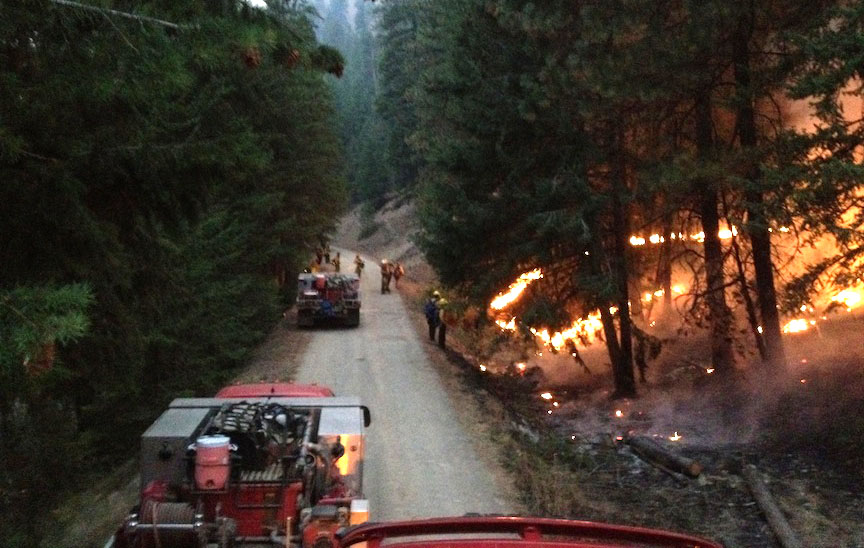
Crews in the Methow Valley battling three major lightning-caused fires are mainly focused on protecting structures near the Buckhorn Fire in Gold Creek, between Carlton and Methow. Firefighters from the Washington Dept. of Natural Resources, Washington Fire District #6 and #15, were to be joined by two interagency hot shot crews today.
A Level 3 evacuation order remains in effect for homes near the Buckhorn Fire. Crews plan to burn out near fire lines to strengthen containment lines to make sure the fire remains contained in some areas.
Containment line was completed around two areas of the Leecher Fire Thursday. Here also, crews burned near the fireline in several areas to deepen and strengthen fire lines. Crews planned a burnout along the south perimeter today, and they are preparing to start mopping up.
Crews and smoke jumpers were successful in lining most of the northern perimeter of the Hunter Fire by Thursday evening. Like the other fires, crews are intentionally burning fuels to strengthen fire lines.
Due to dry fuels, low humidity recovery, and warmer temperatures on the ridges, fire has been active through the night. Predicted hotter and drier conditions with gusty winds may test the firelines on the Buckhorn perimeters through the day. Extreme fire activity is expected.
Road restrictions are still in place on North Fork Gold Creek Forest System Road (FSR) 4340, South Fork Gold Creek FSR 4330, Benson Creek Road FSR 4150, FSR 4150-300, and 4150-200. Trails from Foggy Dew and Crater Creek are also closed at this time.
For Washington regional fire information, please call the regional Joint Information Center (JIC) at 509-664-9374. Follow the JIC twitter account: @inciweb#Wenatchee_WAOWF
 |
|
 |
|
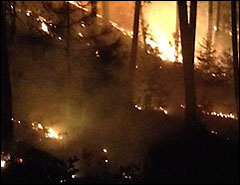 |
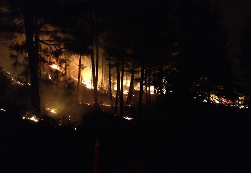
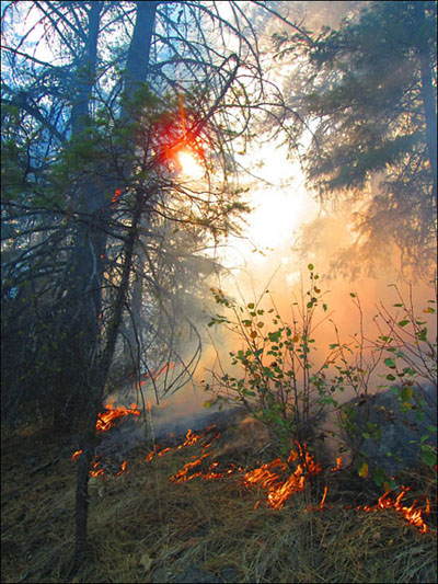
| Photos from the front line. Click images to enlarge. |
Update: Thursday, 9/13, 7pm
The three fires that make up the ‘Okanogan Complex’ in the Methow River drainages near Carlton grew to include 2,518 acres on Thursday, September 13, according to a news release from the Oregon-based team in charge.
Some 275 firefighters are on hand. They are making progress though fire managers are maintaining an evacuation (Level 3) in the Gold Creek area.
The valley’s gradual warming trend is expected to continue on Friday in the fire area. Relative humidities are expected to be in the teens. The combination of lower humidities and higher temperatures, and other weather factors could lead to increased fire activity in the afternoon.
Road restrictions are still in place on North Fork Gold Creek Forest System Road (FSR) 4340, South Fork Gold Creek FSR 4330, Benson Creek Road FSR 4150, FSR 4150-300, and 4150-200. Road closures provide for public safety and allow emergency vehicles safe access. Trails from Foggy Dew and Crater Creek are also closed at this time.
Oregon Interagency Incident Management Team #1’s recent news release stated that “commercial thinning and under-burning treatments completed by the Methow Valley Ranger District have made it possible for firefighting personnel to safely and effectively work in the area. The Leecher fire dramatically slowed in areas that received under-burning treatments this spring.”
No structures have been lost in the fires to date. Safety concerns beyond the fire itself in the area include the steep terrain, snakes, mine shafts and other mining remains, and deer on the roadway, according to the news release.
At a Glance as of 9/13:
- Total Acres: 2,518
- Containment: 2%
- Location: Vicinity of Carlton, Washington
- Cause: Lightning
- Personnel: 275
- Evacuations: A Level 3 evacuation is in place in the Gold Creek Area near the Buckhorn Fire
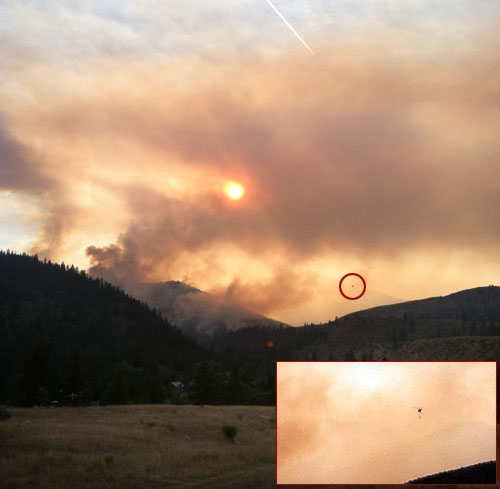 Local Bill Tackman caught the smoky sunset on September 12 near Gold Creek. The speck is a helicopter with a water bucket working the fire.
Update
Wed, 9/12, 8pm
Oregon Interagency Incident Management Team #1 arrived last night and assumed command of the three fires in what is called the 'Okanogan Complex' this morning. The team is establishing an Incident Command Post four miles south of Twisp. The Methow Valley Ranger Station is hosting many team functions while the Incident Command Post is setting up, according to the first news release by the team.
The fires didn't grow much on Tuesday. The Leecher fire, which is the largest, increased by about 100 acres. However, firefighters made good progress on a dozer line around the southern portion of the Leecher fire.
A Level 3 evacuation continues in the Gold Creek area on account of the Buckhorn Fire.
A gradual warming trend is predicted for the complex area this week, with relative humidities lowering into the teens.
"Fire behavior is predicted to be active as temperatures rise. Aircraft are on order to help with fire suppression. Eleven hand crews have also been requested, along with additional engines," the release states.
 Local firefighter Max Jones sent in this photo from the line on the Buckhorn Fire, when the crew was lighting a backfire
Road closures continue:
- North Fork Gold Creek Forest Service Road 4340 is closed to public traffic, but open to local residents and emergency vehicles, from the intersection with South Creek FS Road Number 4330 to the intersection with Forest Road Number 300-700.
- The South Fork Gold Creek Road Number 4330 is closed to all traffic from the intersection with FS Road Number 4340 to the intersection with FS Road Number 4330-200.
- Road closures in the Leecher Mountain area include Benson Creek Road, as well as Roads 4150 and 4150-300, and Roads 4150 and 4150-200 are closed at the forest boundary.
- The closure continues along Roads 4150 and 4150-300, also called the Four Corners. To the south, Road 4100 is closed at the southern boundary of the National Forest, with resident traffic only allowed beginning at Gambles Mill, at the intersection of County Roads 1706 and 1709.
The team also warned motorists that traffic on Highway 153 will increase as additional crews arrive in the area to help.
At a Glance as of 9/12:
- Hunter Mtn. Fire: 169 acres
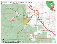
- Buckhorn Fire: 475 acres
- Leecher Fire: 850 acres
- Total Acres: 1,494
- Containment: 2%
- Location: Vicinity of Carlton, Washington
- Cause: Lightning
- Personnel: 212
- Evacuations: A Level 3 evacuation is in place in the Gold Creek Area near the Buckhorn Fire
Update: Possible Power Outage
Wed, 9/12, 9:30am - from the Okanogan PUD: Fires in the area have taken out two Bonneville Power Administration (BPA) transmission lines serving the Okanogan County Public Utility District (PUD). A third BPA transmission line serving Okanogan is currently being threatened. If the line goes out of service the PUD will experience an outage that could potentially impact all of its service area. The PUD is working with other emergency service agencies to avoid or minimize the impact to PUD customers.
Update: Tuesday, 9/11, 8:30pm
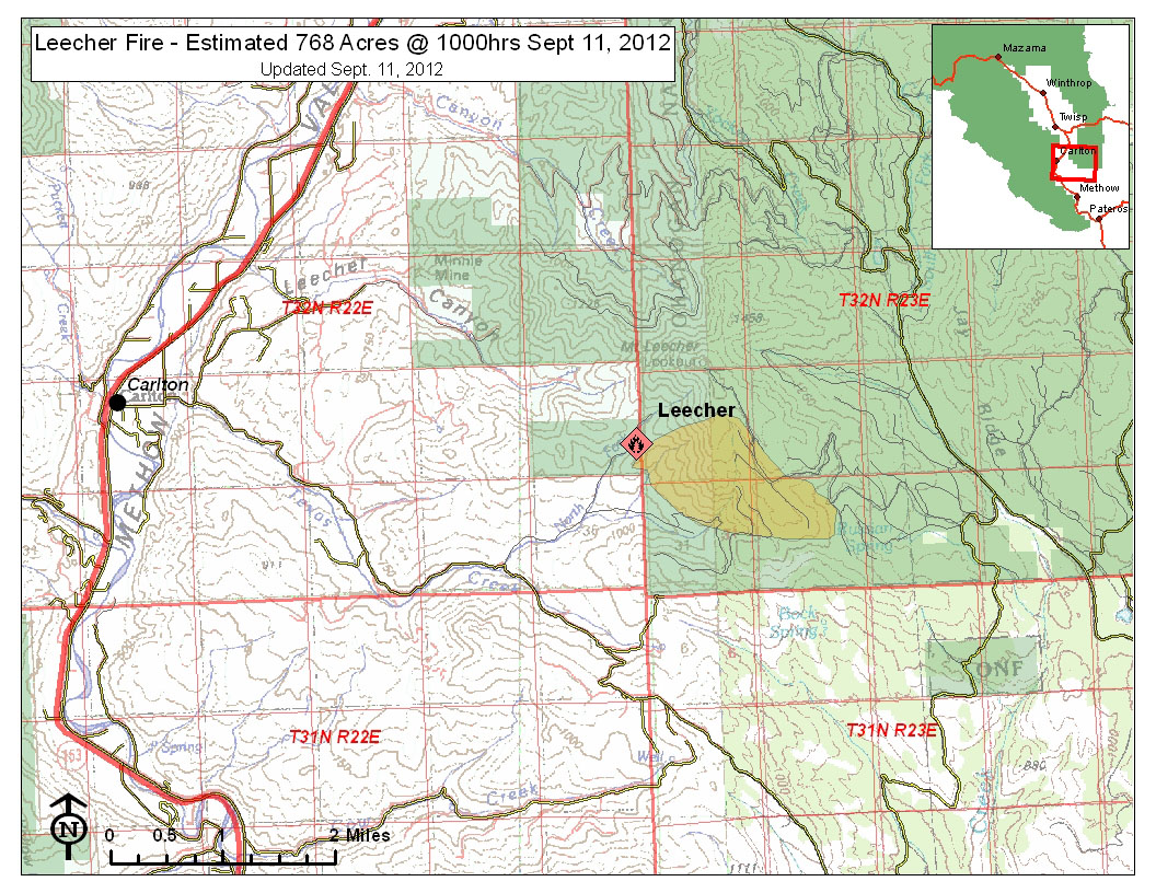
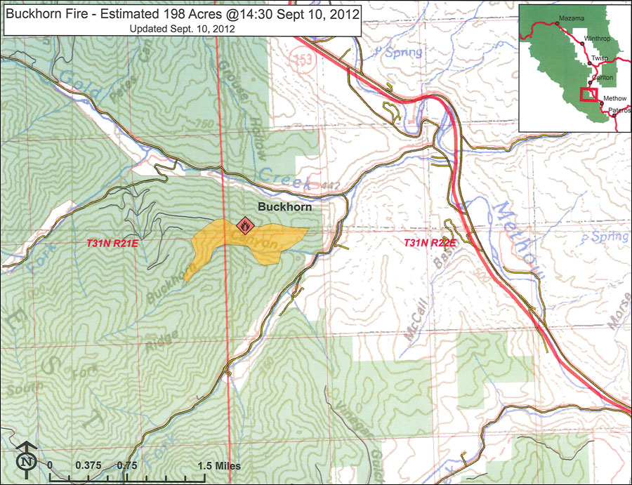
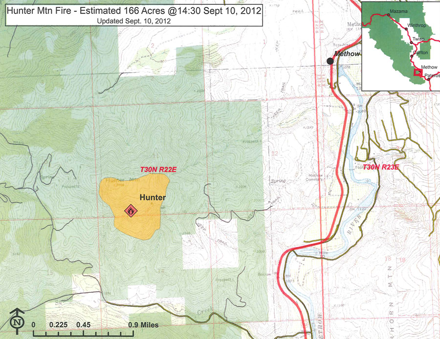
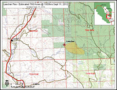
The three main lightining-caused fires burning in the Methow Valley grew today, and pumped smoke into the creeks and valleys. In the early afternoon, the Leecher Fire, in Texas Creek, was estimated at 768 acres, the Buckhorn Fire at 475 acres, and the Hunter Mountain Fire at 169 acres, according to a news release from Kent Woodruff of the Methow Valley Ranger District.
Crews from the Okanogan and Wenatchee National Forest, Washington Department of Natural Resources, and Okanogan County Fire District 6 were successful protecting structures in the South Fork of Gold Creek and keeping all fires from growing significantly despite strong winds and low humidity. However, the Level Three evacuation recommendation remains in effect for all of Gold Creek for at least 24 hours due to the continued threat in the area, Woodruff said.
With cooler temperatures and light winds forecast tonight and tomorrow, along with more firefighter resources arriving, crews are expected to gain some control of these fires as they continue to build fire line and strengthen protection around homes, Woodruff reported. No homes are currently threatened in the Squaw Creek area, or the Texas or French Creek areas.
These local fires are part of the' Okanogan Complex', which includes several fires outside the Methow Valley.
The Northwest Oregon Incident Management Team will be arriving Tuesday evening and will take over management of the three fires in the Okanogan Complex Wednesday.
 |
|
 |
|
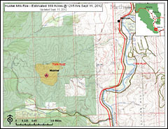 |
| Left to right, maps of the Leecher, Buckhorn and Hunter fires as of 9/11/2012. Click images to enlarge. |
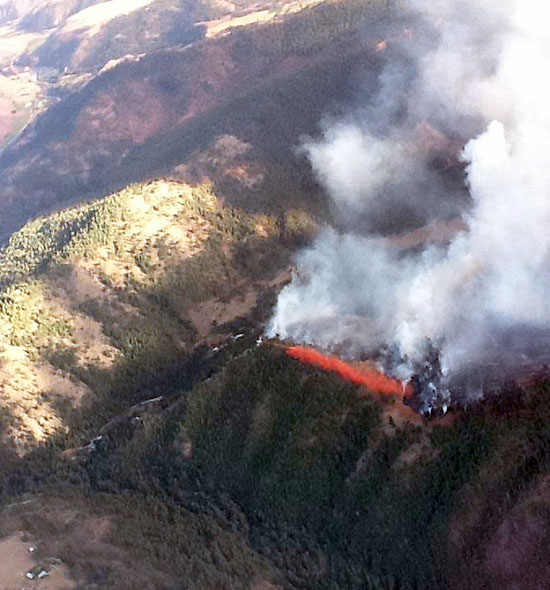 Local Dee Townsend, working as Northeast Air Attack out of Deer Park, Washington, took this photograph of a retardant drop on the the Buckhorn Fire on September 10.
Wildfires
Several lightning starts
Evacuation Order >>
Weekend lightning ignited several fires across north central Washington. Eight of those fires were in Okanogan County on land managed by the Methow Valley Ranger District.
The Hunter Fire, which can be seen from Highway 153 is bigger than 100 acres and sits on the ridge between McFarland and Squaw Creeks. A fire team is on the way: four smoke jumpers are already working on the fire, and planes dropped retardant on the Hunter Fire Sunday.
The Buckhorn Fire on Gold Creek Ridge is also visible from Highway 153. It is estimated to be about 25 acres: two 20-person crews were ordered to the fire Sunday.
Monday morning winds kept the smokejumpers from fires 512, 570 and 571 and another small fire in the Leecher Mountain area, so they headed out over ground. Fire 512 is estimated at 35 acres.
Fire 530 is in the Huckleberry Creek, Sandy Butte area. Fire 542 is in the Buck Mountain area. Both were estimated at less than an acre Monday morning.
A red flag weather warning remained in effect Monday morning for dry fuels as well as gusty winds and low relative humidity.
Okanogan-Wenatchee National Forest leaders have called in Type 1 and 2 incident management teams to help with the numerous fires.
More information is available on our fire page >>
9/10/2012
last updated 9/13/12, 7pm
|
|