 Maybe the oldest MVSTA winter map? The same cover was used into the mid 1990s. Mapping the Maps
MVSTA's cartographic past
story and photos by Charles Hickenbottom
On a trip last winter to the Methow Valley for some cross country skiing, Janet and I checked in at the Mazama Ranch House. Once in our room we noticed that tourist publications were nicely laid out on the table. Prominent on top of the pile was a Methow Valley Sport Trails Association (MVSTA) map. The picture on the cover was an image I didn’t recognize from previous editions of the map that I had brought along. This would be a new map for us to use and I was eager to see what this new edition would include.
We continued our unpacking. In my “Methow Valley” map folder were three older editions of MVSTA cross country trail system maps. Janet also had some trail maps, having two older MVSTA maps in her possession. To my surprise, Janet’s maps were different editions than mine. Along with the new map on the table, we had a total of six different editions of the MVSTA map available to us.
But, getting out to ski was the first order of business. The newest map on the table didn’t show anything for the Mazama area that we didn’t already recognize from previous trips to the area. There’d be plenty of time later for a closer look at the rest of the map.
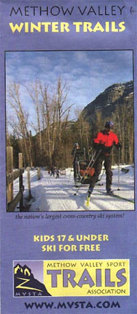 The 2012-13 edition of the map, now advertising free skiing for kids and a website address. The first thing I looked for that night when I got back to looking at the new map was to see if a publication date for the new map was included. I wasn’t surprised when I couldn’t find a date on the map. Over the years I had noticed this ambiguity on previous map editions. I guessed that this allowed for the distribution of a particular edition of the map over a period of more than one ski season without the map appearing to be old.
We’re in for the evening on a winter night. All the maps were now out on the table. I wondered if I could sort the maps into chronological order without having the benefit of publication dates. To use historical clues from the maps in an attempt to put them into a logical order sounded like a fun way to spend some time. Plus, I’ve skied in the Methow Valley for perhaps twenty years. I have a good bit of knowledge about the trails and figured I’d have a pretty good shot at being able to do it accurately.
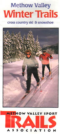
One of Janet’s maps was printed on glossy paper, while the others were not. It was also considerably more faded and wrinkled than the other five. I guessed that it had been in her belt pack for quite some time. This map, which I have titled “Two Track Skiers,” had a picture on the cover that made it appear to be older than the others. The image showed nordic skiing rather than skate skiing and featured a skier wearing a wool sweater, a type of clothing that’s much less common to see today.
Besides the cover picture, the maps within might provide definitive clues. On the Mazama map I recognized an older configuration of the Methow Trail, showing this trail heading south from the Cow Beach Warming Hut towards an intersection with the River Run Trail near the present day Basecamp Trail junction. This portion of the Methow Trail was later abandoned, presumably due to private property issues. Today, only the portion of the Methow Trail that is north of the Cow Beach area still exists. A quick review of the other five maps revealed that each showed a newer configuration of the Methow Trail. This was tangible evidence that “Two Track Skiers” was the oldest map in our collection of six.
Perhaps other features of the map “Two Track Skiers” might help in determining the publication date. An e-mail address for inquiries to MVSTA was listed but no website address was included for the MVSTA. Clearly this map was published when e-mail was available, but before MVSTA had a website. I guessed the publication date as around the mid-1990s.
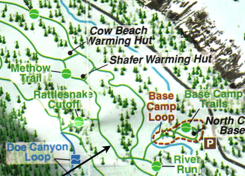 This section of the Methow trail between Cow Beach hut and River Run trail only showed on early MVSTA maps. It was one of the clues the author used to put the maps in chronological order. Reflecting again on the cover picture of “Two Track Skiers”, I wondered about even older versions of the cross country ski maps for the Methow Valley. Perhaps one of these maps would feature a picture of a skier wearing knickers, a style more common in the 1970s and 1980s. Or perhaps an older map might feature the Seattle Mountaineers tradition of that earlier era, which consisted of tights with short pants worn over the top.
Now that I was sure that “Two Track Skiers” was our oldest map, my attention turned to the other maps. Of course, I knew the map “Skiers on Bridge” was the 2012-2013 edition, since it was included in the promotional materials in our motel room. Features on the cover of this map include: advertising “the nation’s largest cross-country ski system!”, advertising “Kids 17 & Under Ski For Free”; and displaying the website address for MVSTA. Unfolding the map and inspecting more carefully revealed other new features: additional retail locations to purchase trail passes; a 200 kilometer promotional incentive for trail users; the website address of a MVSTA Facebook page; a grooming application for smart phones; and a local radio station doing a daily ski report. A graphic arts/mapping company, Amazing Maps <http://www.amazingmaps.us/>, is given credit for designing the various maps which show the MVSTA trail system. Pretty quickly I have done the easy stuff. I have identified “Two Track Skiers” (#1 of six) as the oldest map and “Skiers on Bridge” (#6 of six) as the newest map.
 Another detail used to date the maps was the change allowing dogs on some trails. A quick glance at the covers of the remaining four maps made me realize that identifying the next to newest map (#5 of six) was also going to be easy. “Jack’s Trail” was the only one of the four remaining maps that had a MVSTA logo on the cover similar to the newest map, “Skiers on Bridge.” This logo features a graphic alongside the text showing a trail going up a mountain. The remaining three maps had a logo on the cover similar to the older “Two Track Skiers” that includes text, but not a trail graphic. On the inside pages of “Jack’s Trail” was the 2008-2009 Methow Valley Ice Rink Schedule, a clue which precisely establishes the year of publication for this map. The graphic arts/mapping firm, Amazing Maps, was again given credit for the map design, evidence suggesting that this firm has been involved with the MVSTA map production for a period of several years.
“Jack’s Trail” incorporates a notable feature not available on older maps, the inclusion of mileage markers and trail distances between marked locations and junctions. This was a feature that I had long hoped would be incorporated into MVSTA maps. Older versions of the MVSTA trail map did not have mileage markers, but included lists of distances for most trails and distances for a few loop options. The older maps were a bit ambiguous with regard to determining mileage totals when the route for the day did not precisely match something from the mileage lists. I’m something of a “numbers” guy, logging my skate-skiing miles into my “Mountain Sports” database. The mileage markers allowed me to be quite a bit more accurate in determining the total distance for each day of skiing.
 The author studying MVSTA cross country ski maps and entering data into his laptop. Photo by Janet Stanek Still to be determined was the correct chronological order among the remaining three maps (#2 of six, #3 of six, and #4 of six). I already knew that these three maps were newer than “Two Track Skiers” since all three showed the newer configuration for the Methow Trail. I also knew that all three were older than “Jack’s Trail,” each having the older logo on the cover. Nothing on the covers gave any clues to ordering the maps. Two of the maps, “Skater and Shadow with blue-colored text” and “Skater and Shadow without blue colored text” had an identical cover photo and logo, but differences in the color and text in the title. I will need to dig deeper inside the cover to look for clues as to the chronological order. “Skater and Shadow” (both versions) have identical maps inside. There are differences inside with some blue-colored text headings missing, a pattern already noted for the text on the cover. Perhaps this was a printing error and both versions were printed the same year.
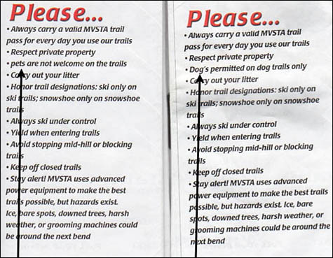
Given the assumption to consider both versions of “Skater and Shadow” as essentially the same map, what’s left in ordering the maps is to determine which came first, “Three Skating Racers” or “Skater and Shadow.” One clue to order the maps involves the evolving policy of the MVSTA with regard to dogs on the trails. Older maps mention “pets are not welcome on the trails.” Newer maps include “dogs’s permitted on dog trails only.” “Three Skating Racers” has the older text. “Skater and Shadow” incorporates the newer text.
So, on an evening in winter when the nights are long, a chunk of time has been spent on a task that might only be of interest to a connoisseur of maps. Now in chronological order are “Two Track Skiers,” “Three Skating Racers.” “Skater and Shadow,” “Jack’s Trail,” and “”Skiers on Bridge.”
And perhaps the evening has produced more questions to ponder while in the process of putting a small collection of maps into chronological order. For example, what are the publication dates for the maps? Only “Jack’s Trail” had a date on it and that was for the Ice Rink schedule for that ski season. How many other maps has MVSTA produced over the years? Surely more than the ones in my possession, I thought. And perhaps there are others in the Methow Valley that have even older maps of the cross country ski trails that were developed prior to the MVSTA era.
But enough map study for tonight. The cross country ski trail is right outside our door. The grooming machine will pass by our room tonight, setting fresh corduroy for tomorrow’s skiers. And of course, I’ll find some pleasure in using the new MVSTA map.
Charles Hickenbottom retired as an elementary school teacher in 2011 after first driving a school bus for eight years and then working as a teacher for an additional 22 years. “Mr. H.” authored a master’s degree project to construct an intermediate elementary map skills curriculum, which he taught to his students for many years. Hundreds of maps in his personal map collection at home attest to his lifelong interest in maps. “Charlie” has map skills in his genes, having a grandfather, father, and two brothers who have all been avid map readers.
Hickenbottom provides support to the rock climbing community in North Central Washington by maintaining an e-mail list of active rock climbers and sending out regular dispatches (“Climbing Chatter”) to the group. His retirement allows additional time towards writing projects and some of his favorite sports including rock climbing, hiking, and skate skiing.
11/15/2013
see past stories in the archive >>
|